
1. When the Obong of Calabar signed a “Treaty of Protection” with Britain on September 10, 1884 Britain agreed to “extend its protection” to the Obong and his Chiefs. The Obong agreed and promised to refrain from entering into any agreements or treaties with foreign nations or Powers without the prior approval of the British Government. That is, he signed away his Kingdom as a British protectorate. This type of subterfuge was carried out with many of our ancestors. All of this was before “Nigeria” was created. Note too that unlike agreements between metropolitan powers these so called protectorate agreements with African Kingdoms did not have precise definitions of boundaries. On November 15, 1893, Britain and Germany defined their boundaries in Africa, supplemented by another agreement on March 19, 1906. These covered British and German Territories from Yola to Lake Chad.
2. In 1900, 1903 and 1906, key declarations made – and militarily enforced – which created the colonies of ‘Northern Nigeria’ and ‘Southern Nigeria’ (inclusive of the Colony of Lagos). The Obong of Calabar was neither consulted nor did he resist. This was all conducted between metropolitan powers and they understood what they were doing. “Protectorates” became “Colonies”. Note the difference.
3. In 1913, Britain – for the colonies of “Southern” and “Northern” Nigeria – and Germany – for “Kamerun” – reached an agreement on their border from Yola to the Sea. The first of these agreements was signed in London on March 11, 1913 titled: “(1) The Settlement of the Frontier between Nigeria and the Cameroons, from Yola to the Sea and (2) The Regulation of Navigation on the Cross River”. The second was signed at Obokum on April 12, 1913 by Hans Detzner, representing Germany, and W. V. Nugent, representing Britain. It addressed the precise demarcation of the Anglo-German Boundary between Nigeria and Kamerun from Yola to the Cross River. There were eight accompanying maps.
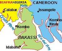
For Bakassi (also spelled Bakasi) peninsula in particular, the Germans were interested in shrimps and an undertaking that Britain would not seek to expand eastwards. The British were interested in uninterrupted and secure sea lane access to Calabar, a key trading post. Since the Germans already had the option of using Douala environs as a port, they conceded the “navigable portion” of the offshore border to Britain. In exchange, Britain conceded the Bakassi peninsula proper to Germany. In other words, to get Germany’s cooperation not to threaten access to Calabar, Bakassi peninsula was conceded by Britain. The Obong did not resist. Note that “Nigeria” did not yet exist. This was long before General Gowon was born.
4. In January 1914, “Nigeria” was created by amalgamation. Neither the Obong nor any other traditional ruler, Emir, or Chief anywhere in “Nigeria” was consulted about it let alone its borders. As was the practice then, it was done for British economic reasons – to extend the railway system of “Northern Nigeria” to the sea and to use excess tax revenues – derived from spirits – from “Southern Nigeria” to correct a budget deficit in “Northern Nigeria”. British and German maps of “Nigeria” from January 1914 clearly show Bakassi peninsula in Kamerun. There was no resistance from the Obong of Calabar or his people or any other native “Nigerians” for that matter.
5. The First World War broke out in 1914. In 1916, Britain invaded German Kamerun. Among the Nigerian troops and carriers fighting for Britain were natives of Nigeria, including some from present Cross- River State. At the end of the war, all German territories were divided between France and Britain by the Treaty of Versailles. The League of Nations placed them under British or French mandate. The boundaries between British and French mandated Kamerun was defined by the Franco-British Declaration of July 10, 1919 by Viscount Milner, the British Secretary of State for the Colonies, and Henry Simon, the French Minister for the Colonies. In this agreement Bakassi and the rest of what became known as “British Cameroons” were placed under British mandate and administered coterminous with “Nigeria” but not actually merged. The old 1913 border was retained. To codify this further, another agreement was signed December 29, 1929 and January 31, 1930 between Sir Graeme Thomson, Governor of the Colony and Protectorate of Nigeria, and Paul Marchand, Commissaire de la République Française au Cameroun. This Declaration was ratified and incorporated in an Exchange of Notes on January 9, 1931 between the French Ambassador in London and the British Foreign Minister. Again, maps from that period show the Bakassi peninsula within “British Cameroons”, not the “Colony and Protectorate of Nigeria”. Neither the Obong nor his people, nor any other “native Nigerians” protested. General Gowon was born a few years later.
6. The Second World War broke out in 1939. Native Nigerians also fought for Britain. After the war, the British and French League of Nations mandates over the Southern and Northern Cameroons and Cameroun were replaced by trusteeship agreements under the new United Nations – approved by the General Assembly on December 13, 1946. These UN agreements re-ratified the prior borders as codified by the previous Anglo-German and Anglo-French agreements. Maps from that period show Bakassi peninsula in the Cameroons, not the real Nigeria.
7. On August 2nd, 1946 Britain divided the Cameroons into two, called “Northern Cameroons” and “Southern Cameroons”. The 1946 ‘Order in Council’ contained detailed provisions describing the border separating these two regions, now conveniently administered from colonial Nigeria – but not part of it.
8. In 1954, the Secretary of State for the Colonies issued a legal order defining the border between Nigeria’s “Eastern region” and the “Southern Cameroons”. Bakassi Peninsula was in the “Southern Cameroons”, distinct from the Eastern region and the Calabar province and maps from that period show this very clearly. General Gowon had not yet joined the Nigerian Army. Neither the Obong nor his people nor any other native Nigerians protested.
9. In March 1959, the UN asked Britain to clarify the wishes of the people living in Northern and Southern Cameroons trusteeship territories in the run up to the “independence” of Nigeria and Cameroun. Maps from that period show Bakassi peninsula in the Cameroons, not the real Nigeria.
10. On January 1st, 1960 the French Cameroons became independent. Instruments creating the new country and exchange of notes between France and Cameroun rehashed all its colonial boundaries as defined by previous colonial agreements.
11. On October 1st, 1960, Nigeria became independent. Instruments creating the new country and exchange of notes between Britain and Nigeria rehashed all its colonial boundaries as defined by previous colonial agreements. Maps dated 1960 show that the Bakassi peninsula was clearly within the “Southern Cameroons”, not “Nigeria proper.” General Gowon was only a subaltern at the time.
12. On February 11th and 12th 1961, a plebiscite was held to ” clarify the wishes of the people living in Northern and Southern Cameroons “. The population of Northern Cameroons had earlier – in 1959 – “decided to achieve independence by joining the independent Federation of Nigeria”, while the population of Southern Cameroons, whose plebiscite could not be done in 1959 for security reasons, now “decided to achieve independence by joining the independent Republic of Cameroon” (General Assembly resolution 1608 (XV) of 21 April 1961). Note that there were 21 polling stations on the Bakassi peninsula itself and that 73% of the people living there voted to “achieve independence by joining the independent Republic of Cameroon”. (Note the blunder here. By spelling it as “Cameroon”, rather than “Cameroun”, the UN created an opening for the people of the “Southern Cameroons” to say they never voted to join “Cameroun” which is the former French territory.
13. In 1962, the government of Tafawa Balewa exchanged diplomatic notes with Cameroun acknowledging the fact that Bakassi was not Nigerian territory. General Gowon was a T/Captain. Maps from that period show Bakassi peninsula in Cameroun, following the results of the 1961 plebiscite.
14. In January 1966, Major General Ironsi came to power in Nigeria. He committed his government to respect all prior international agreements made by the Balewa government. Maps from that period show Bakassi peninsula in Cameroun.
15. In July 1966, then Lt. Col. Gowon came to power in Nigeria. He too committed his government to respect all prior international agreements made by the Ironsi and Balewa governments. Maps from that period show Bakassi peninsula in Cameroun
16. In 1970, moves began to be made by independent Cameroun and post-civil war Nigeria to clarify their maritime border which was vaguely defined by the 1913 Anglo-German Treaty. Maps from that period show Bakassi peninsula in Cameroun, but the offshore boundary was unclear since there was no detailed demarkation of the “navigable portion” of the approach channel to the Calabar estuary. Then Attorney General Elias correctly advised the Gowon government that post-colonial Nigeria had no legal basis for contesting the Bakassi peninsula itself, but that work to delimit the offshore boundary and vague sections of the land boundary should proceed at full speed in accordance with the original Anglo-German Treaty of 1913. The technical problem thus became deciding exactly what part was “navigable” and what was not. It is this matter that was addressed on April 4th, 1971 at Yaoundé when Nigeria’s General Gowon and Cameroun President Ahidjo, accompanied by large delegations, signed the “Coker-Ngo” Line on British Admiralty Chart No. 3433 “as far as the 3-nautical-mile limit.” The status of the Bakassi peninsula proper was not an issue for discussion. Maps from that period show Bakassi peninsula in Cameroun.
17. On June 1st, 1975, Gowon and Ahidjo signed the Maroua Declaration for the partial extension of the 1971 maritime boundary. Again, the status of the Bakassi peninsula proper was not even an issue for discussion. Maps from that period show Bakassi peninsula in Cameroun.
18. On July 29, 1975 General Gowon was overthrown by General Murtala Muhammed. One of the first acts of that regime was to begin to question all the domestic and foreign policy decisions made by General Gowon – including the offshore maritime border with Cameroun. In the rush to smear Gowon publicly, he was held accountable for “giving away Bakassi” – an event that had actually occurred before he was born. Muhammed’s decision to renege on Gowon’s agreements with Ahidjo resonated with a section of the population which had been hoping for a way to get out of its commitments to Cameroun deriving from the 1961 plebiscite and the colonial heritage dating back to 1884. Still, Nigerian official maps from that period and continuing till today except a few that were reprinted on orders from the Babangida government in 1991 show Bakassi peninsula in Cameroun.
19. The rest of what transpired in 1981, 1994, 1996 and since then is well known – including General Abacha’s moves to formally create an administrative set up there and all the military clashes.
20. On October 10, 2002 the International Court at The Hague confirmed what Elias had said in 1970 and reiterated almost a century of colonial agreements which had repeatedly placed Bakassi peninsula inside Kamerun/Cameroon/Cameroun. It also went further to provide guidelines for the final clarification of the offshore border – which if anything, is the only issue about which General Gowon, acting on advice from some civil servants, may not have been as aggressive as he could have been. But even that is a matter of technical detail, not treason.

Leave a Reply